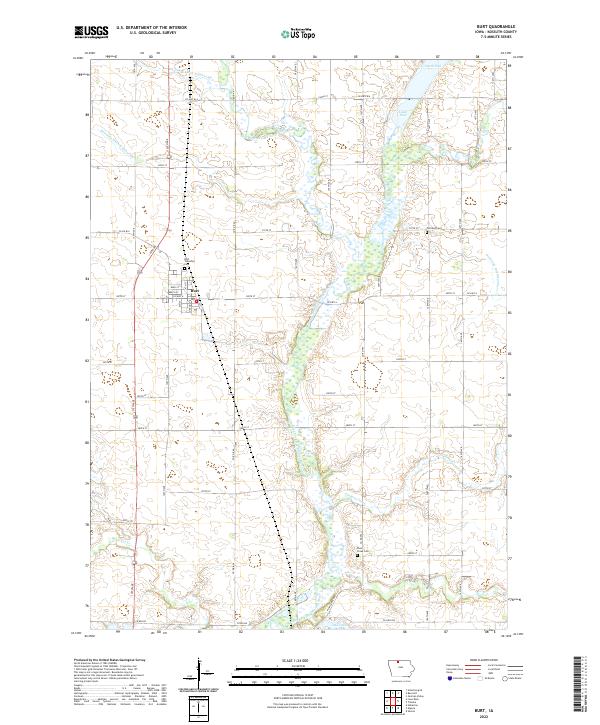
2022 Map of Burt
USGS Topo · Published 2022About this map
Burt serves as the primary settlement in this portion of Kossuth County, situated within a landscape heavily defined by agricultural water management. The East Fork Des Moines River winds through the center of the quadrangle, flanked by numerous wetland areas including Smith Pool and Lowe Pool. The systematic engineering of the terrain is evident in the straight lines of Drainage Ditch Number 69, Drainage Ditch Number 63, and Drainage Ditch Number 17, which redirect water toward the river and its tributaries like Lindsey Creek and Black Cat Cr. For those tracing local family histories, several burial grounds are preserved across the townships, notably Burt Township Cem just north of the town center, Portland Cem to the east, and Plum Creek Cem further south. The map reflects a modern rural Iowa interior where the grid of county roads, such as Co HWY b14 and Co RD b30, dictates the movement between established farmsteads and natural basins like Oak Lake.
Find a feature on this map
33 named features on this map. Tap any name to fly to it.
Don’t see what you’re looking for? This feature index may not catch every label — zoom into the map to look around manually.
Map Details
Editions of this 2022 Burt Map
This is the sole edition of this map. No revisions or reprints were ever made.
Other maps of this area

1954 · Fairmont
USGS Topo · 1:250,000

1958 · Fairmont
USGS Topo · 1:250,000

1972 · German Valley
USGS Topo · 1:24,000

1972 · Algona
USGS Topo · 1:24,000

1972 · Bancroft
USGS Topo · 1:24,000

1972 · Titonka
USGS Topo · 1:24,000

1972 · Burt
USGS Topo · 1:24,000
1972 · Sexton
USGS Topo · 1:24,000

1980 · Lone Rock
USGS Topo · 1:24,000

1980 · Armstrong SE
USGS Topo · 1:24,000