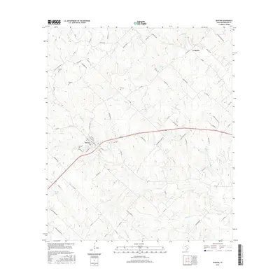
2016 Map of Burton
USGS Topo · Published 2016About this map
Burton sits as the central hub of this Washington County landscape, where the local road network converges near the banks of Mayfield Cr and Indian Cr. The map reveals a high density of rural burial grounds, including Oak Hill Cem, Bethany Cem, and Broesche Cem, which suggest long-standing family settlements throughout the surrounding countryside. This 2016 survey illustrates a patchwork of agricultural land and small water bodies like Mitchell Lake and Lee Lake near the community of Longpoint. The geography is defined by a dendritic drainage system of creeks such as Kerr Cr and Opossum Cr, which have shaped the placement of local thoroughfares like Hoddeville School Rd and Rehburg Rd. For the local historian or genealogist, the distribution of these small cemeteries provides a clear guide to the ancestral hubs of the region.
Find a feature on this map
86 named features on this map. Tap any name to fly to it.
Don’t see what you’re looking for? This feature index may not catch every label — zoom into the map to look around manually.
Map Details
Editions of this 2016 Burton Map
This is the sole edition of this map. No revisions or reprints were ever made.
Other maps of this area

1914 · Gay Hill
USGS Topo · 1:62,500

1930 · Brenham
USGS Topo · 1:62,500

1954 · Austin
USGS Topo · 1:250,000

1956 · Brenham
USGS Topo · 1:62,500

1956 · Somerville
USGS Topo · 1:62,500

1958 · Greenvine
USGS Topo · 1:24,000

1958 · Carmine
USGS Topo · 1:24,000

1958 · Burton
USGS Topo · 1:24,000
1958 · Round Top
USGS Topo · 1:24,000

1959 · Flag Pond
USGS Topo · 1:24,000