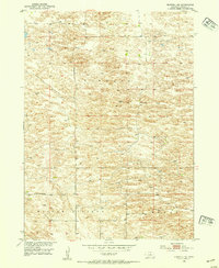
1952 Map of Burwell NE
USGS Topo · Published 1954About this map
Willow Springs and the surrounding Garfield County countryside are documented in this mid-century survey of the Nebraska sandhills. The landscape is dominated by the sprawling Kinkaid and Bryan regions, where the distribution of water is critical, evidenced by several Windmills scattered across the terrain. This map captures a rural social fabric organized around small local institutions, specifically the Kinkaid Sch and the Golden Standard Sch, which served as anchors for the ranching families of the era. The small settlement of Deverre is shown at a crossroad, providing a specific reference point for genealogists and local historians tracing the development of the Missouri River Basin. The topography reveals the complex undulations of the plains, illustrating how early 1950s land use was shaped by the natural contours of the high prairie.
Find a feature on this map
9 named features on this map. Tap any name to fly to it.
Don’t see what you’re looking for? This feature index may not catch every label — zoom into the map to look around manually.
Map Details
Editions of this 1952 Burwell NE Map
3 editions found
Other maps of this area

1952 · Burwell
USGS Topo · 1:24,000

1952 · Burwell SE
USGS Topo · 1:24,000

1952 · Burwell NE
USGS Topo · 1:24,000

1952 · Burwell NW
USGS Topo · 1:24,000

1954 · Gables SW
USGS Topo · 1:24,000

1954 · Gables NW
USGS Topo · 1:24,000

1955 · Broken Bow
USGS Topo · 1:250,000

1955 · O'Neill
USGS Topo · 1:250,000

1956 · Broken Bow
USGS Topo · 1:250,000

1959 · O'Neill
USGS Topo · 1:250,000