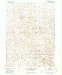
1952 Map of Burwell NE
USGS Topo · Published 1978About this map
Deverre sits within the rural landscape of Garfield County, marking a localized center of settlement in a region defined by large topographic townships. This 1952 survey, updated with aerial data through the late 1970s, reveals a network of country schools that served the dispersed agricultural population, including Kinkaid Sch and Golden Standard Sch. The map illustrates the specialized naming of local terrain areas such as Kinkaid, Willow Springs, and Bryan, providing a rare look at the place-names that shaped the social and geographic identity of this Nebraska prairie. Windmills are scattered throughout the sections, indicating the critical reliance on groundwater management for the area's cattle and farming operations during the mid-20th century.
Find a feature on this map
8 named features on this map. Tap any name to fly to it.
Don’t see what you’re looking for? This feature index may not catch every label — zoom into the map to look around manually.
Map Details
Editions of this 1952 Burwell NE Map
3 editions found
Other maps of this area

1952 · Burwell
USGS Topo · 1:24,000

1952 · Burwell SE
USGS Topo · 1:24,000

1952 · Burwell NE
USGS Topo · 1:24,000

1952 · Burwell NW
USGS Topo · 1:24,000

1954 · Gables SW
USGS Topo · 1:24,000

1954 · Gables NW
USGS Topo · 1:24,000

1955 · Broken Bow
USGS Topo · 1:250,000

1955 · O'Neill
USGS Topo · 1:250,000

1956 · Broken Bow
USGS Topo · 1:250,000

1959 · O'Neill
USGS Topo · 1:250,000