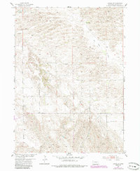
1954 Map of Gables SW
USGS Topo · Published 1985About this map
HO Ranch sits amidst the undulating terrain of this Garfield County landscape, documented during the mid-twentieth century as part of the Missouri River Basin development program. The area is characterized by ephemeral watercourses such as Dry Cedar Creek, which cuts through the northeastern portion of the sheet. The settlement pattern is sparse, reflecting the rural ranching economy of the Nebraska Sandhills where water access was critical for survival. Local education and community infrastructure are represented by School No 7 in the southeast, while the reliance on groundwater is evidenced by several Windmill sites distributed across the land. This survey, updated with 1980s woodland revisions, provides a specific look at the geographic layout of ranching properties and the early educational districts that served this section of the state.
Find a feature on this map
4 named features on this map. Tap any name to fly to it.
Don’t see what you’re looking for? This feature index may not catch every label — zoom into the map to look around manually.
Map Details
Editions of this 1954 Gables SW Map
3 editions found
Other maps of this area

1952 · Elyria
USGS Topo · 1:24,000

1952 · Burwell SE
USGS Topo · 1:24,000

1952 · Burwell NE
USGS Topo · 1:24,000

1954 · Gables SE
USGS Topo · 1:24,000

1954 · Gables SW
USGS Topo · 1:24,000

1954 · Ord NE
USGS Topo · 1:24,000

1954 · Ord NW
USGS Topo · 1:24,000

1954 · Gables NW
USGS Topo · 1:24,000

1954 · Gables
USGS Topo · 1:24,000

1955 · Broken Bow
USGS Topo · 1:250,000