
1954 Map of Gables SE
USGS Topo · Published 1955About this map
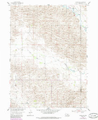
Cedar Creek and its tributary, Dry Cedar Creek, define the topography of this Sandhills region during the mid-1950s. The landscape is characterized by its rolling sand dunes and the intermittent drainage patterns common to Garfield and Wheeler counties. Settlement is sparse, focused primarily on ranching operations as evidenced by the numerous Windmills dotting the sections. Educational infrastructure was already in transition at the time of this survey, shown by the active School No 10 and the nearby School No 10 (Abandoned). This shift reflects the consolidation of rural school districts as motorized transport began to replace horse-drawn travel in the western Nebraska cattle country. The townships of Roosevelt, Dry Cedar, and Ericson are mapped here as part of the larger development of the Missouri River Basin.
Find a feature on this map
9 named features on this map. Tap any name to fly to it.
Don’t see what you’re looking for? This feature index may not catch every label — zoom into the map to look around manually.
Map Details
Editions of this 1954 Gables SE Map
2 editions found
Other maps of this area

1954 · Gables SW
USGS Topo · 1:24,000

1954 · Ord NE
USGS Topo · 1:24,000

1954 · Ord NW
USGS Topo · 1:24,000

1954 · Greeley NW
USGS Topo · 1:24,000

1954 · Gables NW
USGS Topo · 1:24,000

1954 · Bartlett NW
USGS Topo · 1:24,000

1954 · Ericson
USGS Topo · 1:24,000

1954 · Gables
USGS Topo · 1:24,000

1955 · Broken Bow
USGS Topo · 1:250,000

1956 · Broken Bow
USGS Topo · 1:250,000