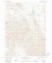
1954 Map of Gables NW
USGS Topo · Published 1985About this map
Big Cedar Creek and Little Cedar Creek wind through this portion of the Nebraska Sandhills, defining a landscape dominated by complex dune formations and small, intermittent wetland pockets. This 1954 survey, updated with photogrammetric data through the 1980s, reveals a territory organized by the township and range system, specifically marking the boundary between T. 23 N. and T. 22 N. The map provides a detailed look at the drainage patterns and topographic relief of Garfield County, where the sparse network of section lines and windmills indicates a land primarily utilized for large-scale ranching and grazing. The intricate contour work illustrates the shifting nature of the local terrain, capturing the precise elevation and orientation of the sandhills before further modernization or land-use changes.
Find a feature on this map
3 named features on this map. Tap any name to fly to it.
Don’t see what you’re looking for? This feature index may not catch every label — zoom into the map to look around manually.
Map Details
Editions of this 1954 Gables NW Map
3 editions found
Other maps of this area

1952 · Burwell SE
USGS Topo · 1:24,000

1952 · Burwell NE
USGS Topo · 1:24,000

1954 · Gables SE
USGS Topo · 1:24,000

1954 · Gables SW
USGS Topo · 1:24,000

1954 · Gables NW
USGS Topo · 1:24,000

1954 · Gables
USGS Topo · 1:24,000

1955 · Broken Bow
USGS Topo · 1:250,000

1955 · O'Neill
USGS Topo · 1:250,000

1956 · Broken Bow
USGS Topo · 1:250,000

1959 · O'Neill
USGS Topo · 1:250,000