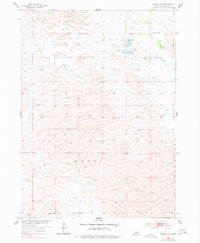
1954 Map of Gables NW
USGS Topo · Published 1978About this map
Little Cedar Creek meanders through the heart of this Sandhills landscape, marking a remote agricultural territory where the borders of Garfield Co and Wheeler Co meet. The 1954 field check reveals a terrain defined by its water sources and rural infrastructure, centered on townships like Bryan and Kinkaid. The distribution of scattered Windmills across the sheet highlights the necessity of groundwater for the ranching operations that have long sustained this Nebraska region. Educational centers such as School No 34 and School No 22 serve as the primary social anchors for the dispersed families of the Missouri River Basin during the mid-20th century, providing a clear view of the settlement patterns before modern consolidation shifted the rural demographic.
Find a feature on this map
8 named features on this map. Tap any name to fly to it.
Don’t see what you’re looking for? This feature index may not catch every label — zoom into the map to look around manually.
Map Details
Editions of this 1954 Gables NW Map
3 editions found
Other maps of this area

1952 · Burwell SE
USGS Topo · 1:24,000

1952 · Burwell NE
USGS Topo · 1:24,000

1954 · Gables SE
USGS Topo · 1:24,000

1954 · Gables SW
USGS Topo · 1:24,000

1954 · Gables NW
USGS Topo · 1:24,000

1954 · Gables
USGS Topo · 1:24,000

1955 · Broken Bow
USGS Topo · 1:250,000

1955 · O'Neill
USGS Topo · 1:250,000

1956 · Broken Bow
USGS Topo · 1:250,000

1959 · O'Neill
USGS Topo · 1:250,000