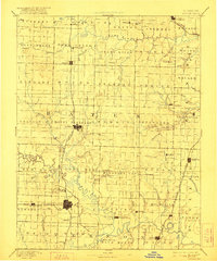
1894 Map of Butler
USGS Topo · Published 1922About this map
The Missouri Pacific Railroad carves a straight north-south path through the center of Bates County, anchoring the growth of Butler and Adrian. This landscape is defined by the convergence of the Grand River and Osage River systems, where numerous small creeks like Mormon Creek and Spruce Creek drain the surrounding prairie. The settlement pattern reveals a transition from river-dependent villages to rail-oriented commerce, with Rich Hill emerging as a significant hub in the south.
Find a feature on this map
96 named features on this map. Tap any name to fly to it.
Don’t see what you’re looking for? This feature index may not catch every label — zoom into the map to look around manually.
Map Details
Editions of this 1894 Butler Map
4 editions found

Other maps of this area

1884 · Fort Scott
USGS Topo · 1:125,000

1885 · Warrensburg
USGS Topo · 1:125,000

1886 · Nevada
USGS Topo · 1:125,000

1886 · Stockton
USGS Topo · 1:125,000

1886 · Fort Scott
USGS Topo · 1:125,000

1887 · Clinton
USGS Topo · 1:125,000

1887 · Harrisonville
USGS Topo · 1:125,000

1887 · Olathe
USGS Topo · 1:125,000

1887 · Butler
USGS Topo · 1:125,000

1887 · Mound City
USGS Topo · 1:125,000