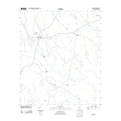
2011 Map of Butler
USGS Topo · Published 2011About this map
Butler serves as the focal point of this west Alabama landscape, situated near the intersection of several regional routes like Desotoville Ave and Vanity Fair Ave. The town’s civic infrastructure is well-defined, ranging from the Butler Post Office to the City of Butler Sewage Lagoon and its associated City of Butler Sewage Lagoon Dam. Beyond the main settlement, the area transitions into a network of rural roads and watercourses, including Pickett Creek and Wahalak Creek. Numerous family and community burial grounds, such as Marvin Cemetery and Bush Cemetery, are scattered across the terrain, offering significant genealogical value. The presence of Morgan Chapel south of the main town and the small community of Mount Sterling to the northeast illustrates the distribution of historic centers across Choctaw County. Significant local landmarks like the Butler-Choctaw County Airport anchor the northeastern corner of the map.
Find a feature on this map
69 named features on this map. Tap any name to fly to it.
Don’t see what you’re looking for? This feature index may not catch every label — zoom into the map to look around manually.
Map Details
Editions of this 2011 Butler Map
This is the sole edition of this map. No revisions or reprints were ever made.
Other maps of this area

1953 · Hattiesburg
USGS Topo · 1:250,000

1953 · Meridian
USGS Topo · 1:250,000

1957 · Meridian
USGS Topo · 1:250,000

1958 · Hattiesburg
USGS Topo · 1:250,000

1965 · Meridian
USGS Topo · 1:250,000

1971 · Ararat
USGS Topo · 1:24,000

1972 · Woods Bluff
USGS Topo · 1:24,000
1974 · Toxey
USGS Topo · 1:24,000

1974 · Lisman
USGS Topo · 1:24,000
1974 · Land
USGS Topo · 1:24,000