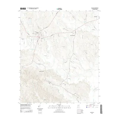
2014 Map of Butler
USGS Topo · Published 2014About this map
Butler serves as the focal point of this Choctaw County landscape, characterized by a complex network of creeks and residential developments including Green Acres. The terrain is defined by the convergence of several major watercourses, most notably Wahalok Creek and its many tributaries, alongside Tishlarka Cr and Middle Tallawampa Cr to the south. This 2014 survey documents the modern layout of the county seat, showing how local transit routes like Al-10 and Al-17 connect the central hub to outlying communities such as Mount Sterling and Morgan Chapel.
Find a feature on this map
77 named features on this map. Tap any name to fly to it.
Don’t see what you’re looking for? This feature index may not catch every label — zoom into the map to look around manually.
Map Details
Editions of this 2014 Butler Map
This is the sole edition of this map. No revisions or reprints were ever made.
Other maps of this area

1953 · Hattiesburg
USGS Topo · 1:250,000

1953 · Meridian
USGS Topo · 1:250,000

1957 · Meridian
USGS Topo · 1:250,000

1958 · Hattiesburg
USGS Topo · 1:250,000

1965 · Meridian
USGS Topo · 1:250,000

1971 · Ararat
USGS Topo · 1:24,000

1972 · Woods Bluff
USGS Topo · 1:24,000
1974 · Toxey
USGS Topo · 1:24,000

1974 · Lisman
USGS Topo · 1:24,000
1974 · Land
USGS Topo · 1:24,000