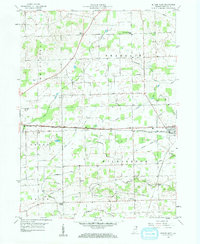
1958 Map of Butler West
USGS Topo · Published 1959About this map
Agricultural life in eastern Indiana is defined by a dense network of water management features, such as Matson Ditch and Haverstock Ditch, which crisscross the townships of Franklin, Smithfield, Grant, and Wilmington. The city of Butler serves as the primary eastern hub, positioned at the intersection of the New York Central railroad and a significant highway corridor. The landscape is dotted with smaller rural landmarks that were central to the community, including Franklin Center Sch and Norris Chapel.
Find a feature on this map
30 named features on this map. Tap any name to fly to it.
Don’t see what you’re looking for? This feature index may not catch every label — zoom into the map to look around manually.
Map Details
Editions of this 1958 Butler West Map
2 editions found
Other maps of this area

1939 · Hamilton
USGS Topo · 1:24,000

1940 · Metz
USGS Topo · 1:24,000

1942 · Ashley
USGS Topo · 1:24,000

1948 · Hamilton
USGS Topo · 1:24,000

1953 · Fort Wayne
USGS Topo · 1:250,000

1956 · Fort Wayne
USGS Topo · 1:250,000

1957 · Auburn
USGS Topo · 1:24,000

1957 · Waterloo
USGS Topo · 1:24,000

1958 · Hicksville
USGS Topo · 1:24,000

1958 · Butler West
USGS Topo · 1:24,000