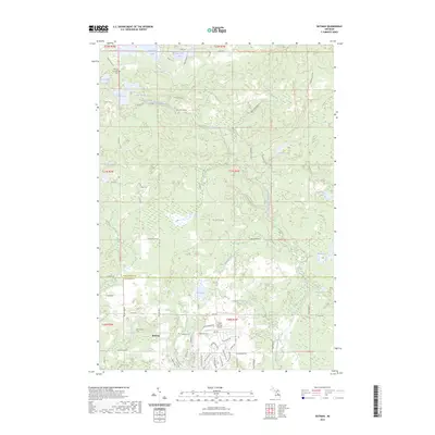
2023 Map of Butman
USGS Topo · Published 2023About this map
The settlement of Butman and its surrounding northern Michigan woodlands are defined by a complex network of glacial lakes and small tributaries. Family history and local heritage are preserved in several distinct locations, including the Nester Township Cem, Nolan Cem, and Butman Cem. The landscape is heavily influenced by the winding course of the West Branch Tittabawassee River, which drains a series of water bodies such as Dunham Lake and Lake Four. Evidence of former industry and modern recreation is visible throughout the area, from an old Railroad Grade cutting across the northern reaches to the Sugar Springs Airpark in the south. These features, along with significant trails like the Midland-to-Mackinaw Boy Scout Trl, illustrate the transition from a resource-based economy to a region focused on conservation and seasonal aviation.
Find a feature on this map
77 named features on this map. Tap any name to fly to it.
Don’t see what you’re looking for? This feature index may not catch every label — zoom into the map to look around manually.
Map Details
Editions of this 2023 Butman Map
This is the sole edition of this map. No revisions or reprints were ever made.
Other maps of this area

1954 · Traverse City
USGS Topo · 1:250,000

1958 · Traverse City
USGS Topo · 1:250,000

1963 · Backus Lake
USGS Topo · 1:24,000

1965 · St. Helen
USGS Topo · 1:24,000

1965 · Ogemaw Springs
USGS Topo · 1:24,000

1969 · Meredith
USGS Topo · 1:24,000

1969 · Edwards
USGS Topo · 1:24,000

1969 · Butman
USGS Topo · 1:24,000

1969 · Wagarville
USGS Topo · 1:24,000
1969 · Skeels
USGS Topo · 1:24,000