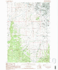
1989 Map of Butte South
USGS Topo · Published 1989About this map
Butte sits at the northern edge of this study, where the industrial legacy of the copper mining district meets the foothills of the Deerlodge National Forest. The map documents a complex landscape of early urban development and environmental management, featuring the Sewage Disposal Plant and expansive Tailings deposits near Silver Bow Creek. Local heritage is anchored by a significant cluster of religious and community burial grounds, including Mount Moriah Cemetery, St Patrick Cemetery, and the B'Nai Israel Cem.
Find a feature on this map
43 named features on this map. Tap any name to fly to it.
Don’t see what you’re looking for? This feature index may not catch every label — zoom into the map to look around manually.
Map Details
Editions of this 1989 Butte South Map
2 editions found
Other maps of this area

1889 · Helena
USGS Topo · 1:250,000

1893 · Helena
USGS Topo · 1:250,000

1893 · Dillon
USGS Topo · 1:250,000

1899 · Boulder
USGS Topo · 1:125,000

1899 · Helena
USGS Topo · 1:250,000

1903 · Helena
USGS Topo · 1:250,000

1947 · Butte
USGS Topo · 1:250,000

1954 · Elk Park
USGS Topo · 1:62,500

1955 · Dillon
USGS Topo · 1:250,000

1957 · Dillon
USGS Topo · 1:250,000