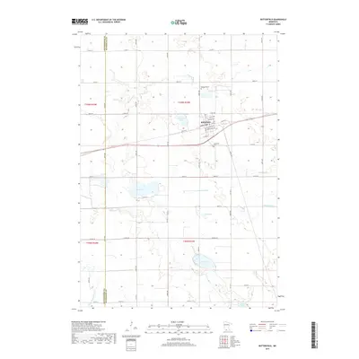
2019 Map of Butterfield
USGS Topo · Published 2019About this map
Butterfield sits at the heart of this prairie landscape, a hub defined by its intersection of rail and road near the headwaters of Butterfield Cr. The town’s social and religious history is anchored by the Mennonite Cem to the north and the Butterfield Cem to the south, reflecting the community's ancestral roots and settlement patterns. The surrounding terrain is a mosaic of glacial depressions and drainage networks, where Butterfield Lake and Sulem Lake break the grid of section lines. To the south and east, the landscape transitions into more significant water features, including School Lake, Mud Lake, and the winding path of Saint James Cr. The southern edge of the survey is defined by the S Fork Watonwan River, showing the importance of these watercourses in shaping the early agricultural development of Watonwan and Cottonwood counties.
Find a feature on this map
41 named features on this map. Tap any name to fly to it.
Don’t see what you’re looking for? This feature index may not catch every label — zoom into the map to look around manually.
Map Details
Editions of this 2019 Butterfield Map
This is the sole edition of this map. No revisions or reprints were ever made.
Other maps of this area

1953 · New Ulm
USGS Topo · 1:250,000

1954 · Fairmont
USGS Topo · 1:250,000

1957 · New Ulm
USGS Topo · 1:250,000

1958 · New Ulm
USGS Topo · 1:250,000

1958 · Fairmont
USGS Topo · 1:250,000

1967 · New Ulm
USGS Topo · 1:250,000

1967 · Godahl
USGS Topo · 1:24,000

1967 · Darfur
USGS Topo · 1:24,000
1967 · Comfrey
USGS Topo · 1:24,000
1970 · Butterfield
USGS Topo · 1:24,000