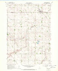
1967 Map of Comfrey
USGS Topo · Published 1969About this map
The town of Comfrey sits at the intersection of the Chicago and North Western railroad and the county line during the late 1960s. This agricultural landscape in Southern Minnesota is defined by the winding course of the Watonwan River and its North Fork, which carve through the townships of Selma, Delton, and Bashaw. The survey reveals a highly organized rural grid, where landmarks like the Christian Reformed Ch and Congregational Cem serve as focal points for the surrounding farmsteads. Significant land alterations are visible through the inclusion of County Ditch No 39 and localized industrial features such as a Gravel Pit. The map captures the area just as modern infrastructure, like the town's Sewage Disposal plant, was being integrated into the traditional prairie river valley environment.
Find a feature on this map
16 named features on this map. Tap any name to fly to it.
Don’t see what you’re looking for? This feature index may not catch every label — zoom into the map to look around manually.
Map Details
Editions of this 1967 Comfrey Map
This is the sole edition of this map. No revisions or reprints were ever made.
Other maps of this area

1953 · New Ulm
USGS Topo · 1:250,000

1954 · Fairmont
USGS Topo · 1:250,000

1957 · New Ulm
USGS Topo · 1:250,000

1958 · New Ulm
USGS Topo · 1:250,000

1958 · Fairmont
USGS Topo · 1:250,000

1967 · New Ulm
USGS Topo · 1:250,000

1967 · Sanborn SE
USGS Topo · 1:24,000

1967 · Springfield
USGS Topo · 1:24,000

1967 · Sanborn NE
USGS Topo · 1:24,000

1967 · Darfur
USGS Topo · 1:24,000