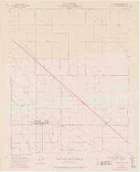
1954 Map of Buttonwillow
USGS Topo · Published 1976About this map
Agricultural development and water management dominate this landscape in the San Joaquin Valley, where the Southern Pacific railroad line cuts a straight path across the terrain. The community of Buttonwillow serves as a central hub, surrounded by a complex network of irrigation infrastructure including the Eightyfoot Canal, Palomas Canal, and numerous named ditches like the Garden Ditch and Whittier Ditch. This intricate water system reflects the region's transition into a highly managed farming environment during the mid-20th century.
Find a feature on this map
40 named features on this map. Tap any name to fly to it.
Don’t see what you’re looking for? This feature index may not catch every label — zoom into the map to look around manually.
Map Details
Editions of this 1954 Buttonwillow Map
3 editions found
Other maps of this area

1910 · Buena Vista Lake
USGS Topo · 1:125,000

1912 · McKittrick
USGS Topo · 1:125,000

1912 · Buena Vista Lake
USGS Topo · 1:125,000

1914 · Lost Hills
USGS Topo · 1:125,000

1927 · Semitropic
USGS Topo · 1:31,680

1929 · Coles Levee
USGS Topo · 1:31,680

1930 · Leonards
USGS Topo · 1:31,680

1930 · Wasco
USGS Topo · 1:31,680

1931 · Rio Bravo
USGS Topo · 1:31,680

1931 · Lokern
USGS Topo · 1:31,680