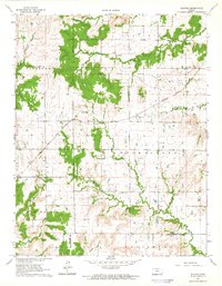
1964 Map of Buxton
USGS Topo · Published 1965About this map
The Atchison Topeka and Santa Fe railway cuts a diagonal path through this landscape, serving the settlement of Buxton and passing near the local Townhall. This mid-century survey captures a rural environment defined by its watercourses and early jurisdictional lines, most notably the Old Indian Treaty Boundary that segments the northern half of the quadrangle. Small-scale civic life is evident through a network of country schools and burial grounds, including West Rainbow Sch and the Upola Cem near the small community of Upola. The terrain is characterized by the convergence of several major drainage systems, including the Fall River and the complex branches of Duck Creek. These creeks divide the upland areas of Painterhood and Louisburg, creating a varied topography that shaped the placement of local homesteads and the early regional road network.
Find a feature on this map
27 named features on this map. Tap any name to fly to it.
Don’t see what you’re looking for? This feature index may not catch every label — zoom into the map to look around manually.
Map Details
Editions of this 1964 Buxton Map
This is the sole edition of this map. No revisions or reprints were ever made.
Other maps of this area

1885 · Eureka
USGS Topo · 1:125,000

1885 · Sedan
USGS Topo · 1:125,000

1886 · Fredonia
USGS Topo · 1:125,000

1886 · Independence
USGS Topo · 1:125,000

1888 · Eureka
USGS Topo · 1:125,000

1889 · Sedan
USGS Topo · 1:125,000

1894 · Fredonia
USGS Topo · 1:125,000

1894 · Independence
USGS Topo · 1:125,000

1894 · Eureka
USGS Topo · 1:125,000

1905 · Independence
USGS Topo · 1:125,000