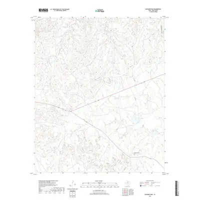
2019 Map of Buzzard Peak
USGS Topo · Published 2019About this map
Buzzard Peak anchors the southern portion of this King County landscape, overlooking a complex network of canyons and drainages characteristic of the Texas Rolling Plains. The northern boundary is defined by the South Wichita River, where the terrain begins its ascent toward the higher breaks. Between these points, the map reveals a remote ranching landscape etched by seasonal waterways such as Spring Cr and Little Croton Cr, which carved the deep incisions of Big Getaway Canyon and Dikes Cr. This late-second-decade survey shows a territory primarily managed through large-scale landholdings, with transportation limited to established routes like Co RD 375 and Co RD 377 that navigate the varied elevations of the breaks. The intricate contour lines illustrate the sharp transitions between flat-topped mesas and the eroding canyon floors that have historically defined northern Texas cattle country.
Find a feature on this map
9 named features on this map. Tap any name to fly to it.
Don’t see what you’re looking for? This feature index may not catch every label — zoom into the map to look around manually.
Map Details
Editions of this 2019 Buzzard Peak Map
This is the sole edition of this map. No revisions or reprints were ever made.
Other maps of this area

1954 · Lubbock
USGS Topo · 1:250,000

1954 · Wichita Falls
USGS Topo · 1:250,000

1958 · Wichita Falls
USGS Topo · 1:250,000

1966 · Ox Yoke Creek
USGS Topo · 1:24,000

1966 · J Y Ranch
USGS Topo · 1:24,000

1966 · Maverick Flat
USGS Topo · 1:24,000

1967 · Cedar Mountain
USGS Topo · 1:24,000

1967 · Dark Canyon
USGS Topo · 1:24,000

1967 · Knox City NW
USGS Topo · 1:24,000

1967 · Kiowa Peak NW
USGS Topo · 1:24,000