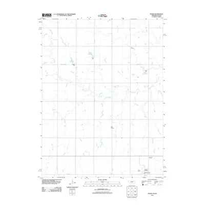
2011 Map of Byron
USGS Topo · Published 2011About this map
Byron anchors the southeastern corner of this Nebraska-Kansas border region, serving as the primary hub for the surrounding agricultural community. The landscape is defined by the winding course of Spring Creek and Otter Creek, which are supplemented by essential water management features such as Hofts Reservoir, Eggers Reservoir, and Fintel Reservoir. These reservoirs, managed by corresponding dams like Hofts Dam and Eggers Dam, highlight the region's reliance on managed water resources for its farming economy. The presence of Zion Cemetery and Saint Pauls Cemetery provides important touchpoints for genealogical research, while the Byron Post Office and Byron Airport reflect the town's role as a local center for commerce and transportation along the state line.
Find a feature on this map
16 named features on this map. Tap any name to fly to it.
Don’t see what you’re looking for? This feature index may not catch every label — zoom into the map to look around manually.
Map Details
Editions of this 2011 Byron Map
This is the sole edition of this map. No revisions or reprints were ever made.
Other maps of this area

1892 · Concordia
USGS Topo · 1:125,000

1898 · Hebron
USGS Topo · 1:125,000

1955 · Manhattan
USGS Topo · 1:250,000

1955 · Lincoln
USGS Topo · 1:250,000

1956 · Manhattan
USGS Topo · 1:250,000

1957 · Manhattan
USGS Topo · 1:250,000

1957 · Lincoln
USGS Topo · 1:250,000

1958 · Lincoln
USGS Topo · 1:250,000

1960 · Byron
USGS Topo · 1:24,000
1960 · Oak
USGS Topo · 1:24,000