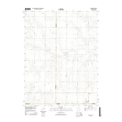
2014 Map of Byron
USGS Topo · Published 2014About this map
The village of Byron anchors the southern edge of this survey at the state line where Nebraska meets Kansas. Situated in the Republican River valley region, the landscape is defined by an orderly grid of section roads including Road A through Road J, which segment the agricultural terrain between the Nuckolls and Thayer county boundaries. Water management is a visible priority across the prairie, evidenced by numerous named impoundments such as Eggers Reservoir, Hofts Reservoir, and Fintel Reservoir, which capture runoff from drainage systems like Spring Cr and Otter Cr. For genealogists, the map identifies local burial sites including Zion Cem in the north and two locations for Saint Pauls Cem near the town site. The intersection of Ne-8 and local thoroughfares like N Kansas Ave and Warren St illustrates the infrastructure supporting this border community.
Find a feature on this map
24 named features on this map. Tap any name to fly to it.
Don’t see what you’re looking for? This feature index may not catch every label — zoom into the map to look around manually.
Map Details
Editions of this 2014 Byron Map
This is the sole edition of this map. No revisions or reprints were ever made.
Other maps of this area

1892 · Concordia
USGS Topo · 1:125,000

1898 · Hebron
USGS Topo · 1:125,000

1955 · Manhattan
USGS Topo · 1:250,000

1955 · Lincoln
USGS Topo · 1:250,000

1956 · Manhattan
USGS Topo · 1:250,000

1957 · Manhattan
USGS Topo · 1:250,000

1957 · Lincoln
USGS Topo · 1:250,000

1958 · Lincoln
USGS Topo · 1:250,000

1960 · Byron
USGS Topo · 1:24,000
1960 · Oak
USGS Topo · 1:24,000