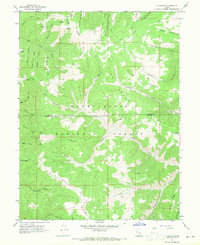
1967 Map of C Canyon
USGS Topo · Published 1970About this map
Manti-La Sal National Forest defines this high-elevation landscape, where the boundary between Utah and Sanpete Counties runs through a series of prominent ridges and deep canyons. The survey captures the transition from historic transportation routes like the Wagon Road to the modern engineering of Skyline Drive and a utility Pipeline traversing the southern terrain. This area is characterized by a dense network of water sources, including Garret Spring Fork, Rock Spring, and the headwaters of Thistle Creek. The naming of features such as Loggers Fork, Sawmill Canyon, and Beehive Ridge suggests a history of timber extraction and land use. Geographers and local historians can trace the intricate drainage systems of Fish Creek and Bennion Creek as they cut through the heavily contoured topography of Haystack Ridge and Johnson Ridge.
Find a feature on this map
49 named features on this map. Tap any name to fly to it.
Don’t see what you’re looking for? This feature index may not catch every label — zoom into the map to look around manually.
Map Details
Editions of this 1967 C Canyon Map
This is the sole edition of this map. No revisions or reprints were ever made.
Other maps of this area

1885 · Manti
USGS Topo · 1:250,000

1895 · Manti
USGS Topo · 1:250,000

1923 · Scofield
USGS Topo · 1:62,500

1925 · Scofield
USGS Topo · 1:62,500

1939 · Soldier Summit
USGS Topo · 1:62,500

1942 · Soldier Summit
USGS Topo · 1:62,500

1956 · Price
USGS Topo · 1:250,000

1960 · Price
USGS Topo · 1:250,000

1962 · Price
USGS Topo · 1:250,000

1965 · Fairview Lakes
USGS Topo · 1:24,000