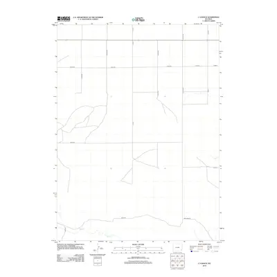
2012 Map of C S Ranch
USGS Topo · Published 2012About this map
Bear Cr and Fox Cr define the hydrological landscape of this section of Laramie County, Wyoming, as it appeared in the early 21st century. The map reveals a highly structured grid of section lines and rural thoroughfares typical of the American West's high plains, where ranching and agricultural boundaries dictate the path of travel. Primary access is facilitated by a network of named routes such as Lancer Rd, Marsh Rd, and S Cs Rd. The survey highlights the intersection of public land survey systems with practical ranch access, including family-named landmarks like S Baker Rd, S Meeker Rd, and Horton Rd. This topographic study provides a clear view of the area's development before more recent suburban or industrial shifts, preserving the exact layout of drainage and property access roads like Bear Creek Rd and Range Rd.
Find a feature on this map
19 named features on this map. Tap any name to fly to it.
Don’t see what you’re looking for? This feature index may not catch every label — zoom into the map to look around manually.
Map Details
Editions of this 2012 C S Ranch Map
This is the sole edition of this map. No revisions or reprints were ever made.
Other maps of this area

1953 · Chugwater
USGS Topo · 1:24,000

1954 · Cheyenne
USGS Topo · 1:250,000

1958 · Cheyenne
USGS Topo · 1:250,000

1962 · Moffett Ranch
USGS Topo · 1:24,000

1962 · Bristol Ridge NE
USGS Topo · 1:24,000

1963 · C S Ranch
USGS Topo · 1:24,000

1963 · Y B O Canyon
USGS Topo · 1:24,000
1963 · Cattail Ranch
USGS Topo · 1:24,000

1963 · Klutz Canyon
USGS Topo · 1:24,000
1963 · Cattail Ranch NE
USGS Topo · 1:24,000