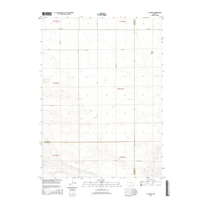
2015 Map of C S Ranch
USGS Topo · Published 2015About this map
C S Ranch serves as a primary landmark in this corner of Wyoming, where the high plains terrain of Iowa Center Flats dominates the landscape. The map captures a complex intersection of county lines, where Platte, Goshen, and Laramie Counties converge. This 2015 survey reveals a land defined by its section-line road network, including Lone Tree Rd and Road 1, which facilitate travel through the expansive ranching country. Intermittent water sources like Bear Cr and Fox Cr carve subtle drainage patterns across the terrain, while routes like Bear Creek Rd and Lancer Rd provide access to remote acreage. The arrangement of these roads and the namesake ranch suggest a landscape where large-scale agricultural operations and local land management have established a lasting footprint on the territory.
Find a feature on this map
28 named features on this map. Tap any name to fly to it.
Don’t see what you’re looking for? This feature index may not catch every label — zoom into the map to look around manually.
Map Details
Editions of this 2015 C S Ranch Map
This is the sole edition of this map. No revisions or reprints were ever made.
Other maps of this area

1953 · Chugwater
USGS Topo · 1:24,000

1954 · Cheyenne
USGS Topo · 1:250,000

1958 · Cheyenne
USGS Topo · 1:250,000

1962 · Moffett Ranch
USGS Topo · 1:24,000

1962 · Bristol Ridge NE
USGS Topo · 1:24,000

1963 · C S Ranch
USGS Topo · 1:24,000

1963 · Y B O Canyon
USGS Topo · 1:24,000
1963 · Cattail Ranch
USGS Topo · 1:24,000

1963 · Klutz Canyon
USGS Topo · 1:24,000
1963 · Cattail Ranch NE
USGS Topo · 1:24,000