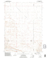
1990 Map of C S Ranch
USGS Topo · Published 1995About this map
Chugwater Flats and Iowa Center Flats dominate this landscape, illustrating the broad plateau topographies where Laramie, Platte, and Goshen counties converge. The mapping reveals a sparse ranching economy centered on family-named operations like the C S Ranch and A X Ranch, with life tied closely to the few available water sources. In the southern portion of the quadrangle, Bear Creek cuts through the terrain, while Fox Cr and several scattered Well sites provide the essential infrastructure for livestock in an otherwise arid expanse. The presence of a long Pipeline crossing the western sections highlights the industrial utility of these open spaces, contrasting with the traditional boundaries of the triple-county corner. This 1990 revision shows the persistence of large-scale landholdings in a region where geography and resource management define the settlement pattern.
Find a feature on this map
11 named features on this map. Tap any name to fly to it.
Don’t see what you’re looking for? This feature index may not catch every label — zoom into the map to look around manually.
Map Details
Editions of this 1990 C S Ranch Map
This is the sole edition of this map. No revisions or reprints were ever made.
Other maps of this area

1953 · Chugwater
USGS Topo · 1:24,000

1954 · Cheyenne
USGS Topo · 1:250,000

1958 · Cheyenne
USGS Topo · 1:250,000

1962 · Moffett Ranch
USGS Topo · 1:24,000

1962 · Bristol Ridge NE
USGS Topo · 1:24,000

1963 · C S Ranch
USGS Topo · 1:24,000

1963 · Y B O Canyon
USGS Topo · 1:24,000
1963 · Cattail Ranch
USGS Topo · 1:24,000

1963 · Klutz Canyon
USGS Topo · 1:24,000
1963 · Cattail Ranch NE
USGS Topo · 1:24,000