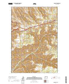
2020 Map of Cabbage Hill
USGS Topo · Published 2020About this map
Cabbage Hill and the surrounding high country of Umatilla County are defined by a complex network of canyons and ridges that have historically dictated the passage of travelers through this part of the Blue Mountains. The modern transportation corridor roughly follows the path of the Old Oregon Trl, winding past Emigrant Hill and through the notorious Deadman Pass. The landscape is carved by numerous seasonal and perennial waterways, including N Fork McKay Cr and Cottonwood Cr, which descend from high points like Kanine Ridge. At the southern edge of the quadrangle lies the settlement of McKay, situated where the terrain begins to transition toward the broader valley. The names scattered across the topography, such as Red Hawk Gulch and Doe Canyon, reflect a long history of local land use and geographic orientation in this corner of Oregon.
Find a feature on this map
38 named features on this map. Tap any name to fly to it.
Don’t see what you’re looking for? This feature index may not catch every label — zoom into the map to look around manually.
Map Details
Editions of this 2020 Cabbage Hill Map
This is the sole edition of this map. No revisions or reprints were ever made.
Other maps of this area

1935 · Pendleton
USGS Topo · 1:125,000

1953 · Pendleton
USGS Topo · 1:250,000

1956 · Pendleton
USGS Topo · 1:250,000

1963 · Meacham Lake
USGS Topo · 1:24,000

1964 · Thorn Hollow
USGS Topo · 1:24,000

1964 · Meacham
USGS Topo · 1:24,000

1966 · Cabbage Hill
USGS Topo · 1:24,000
1966 · Cayuse
USGS Topo · 1:24,000

1966 · Table Rock
USGS Topo · 1:24,000

1966 · Mission
USGS Topo · 1:24,000