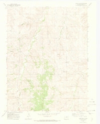
1970 Map of Cabin Gulch
USGS Topo · Published 1973About this map
Running Creek carves a central path through this section of Elbert County, defining a landscape of drainage systems that include Timber Claim Gulch, Cabin Gulch, and the aptly named Whiskey Gulch. This 1970 field-checked survey reveals a rural territory transitioning into the late twentieth century, where traditional land markers like the Miller Cem and several Gravel Pit sites coexist with more modern infrastructure. A notable Landing Strip and a Radio Tower indicate the increasing importance of aerial and electronic connectivity in this open terrain. For those interested in local social history, the Church Camp situated near the headwaters of the creek network provides a specific point of cultural interest. The map's fine red dashed lines reveal established fence lines, offering a glimpse into the property divisions and agricultural boundaries of the era.
Find a feature on this map
16 named features on this map. Tap any name to fly to it.
Don’t see what you’re looking for? This feature index may not catch every label — zoom into the map to look around manually.
Map Details
Editions of this 1970 Cabin Gulch Map
4 editions found
Other maps of this area

1890 · East Denver
USGS Topo · 1:125,000

1894 · Castle Rock
USGS Topo · 1:125,000

1913 · Castle Rock
USGS Topo · 1:125,000

1939 · Elizabeth
USGS Topo · 1:62,500

1940 · Piney Creek
USGS Topo · 1:24,000

1942 · Piney Creek
USGS Topo · 1:31,680

1945 · Elizabeth
USGS Topo · 1:62,500

1953 · Denver
USGS Topo · 1:250,000

1955 · Watkins SE
USGS Topo · 1:24,000

1957 · Denver
USGS Topo · 1:250,000