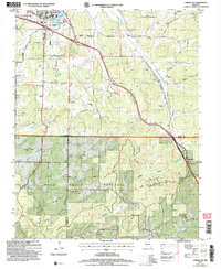
2004 Map of Cabool SE
USGS Topo · Published 2006About this map
The Big Piney River flows through the northwestern corner of this landscape, where the settlement of Cabool sits at a junction of rail and road. Moving south, the terrain becomes increasingly defined by the deep drainages of the Mark Twain National Forest, including Riley Hollow and Tick Hollow. The map reveals a high density of rural institutions that speak to the area's genealogical history, from the Union School to several family and community burial grounds such as Cedar Bluff Cem and the Jones Cemetery.
Find a feature on this map
48 named features on this map. Tap any name to fly to it.
Don’t see what you’re looking for? This feature index may not catch every label — zoom into the map to look around manually.
Map Details
Editions of this 2004 Cabool SE Map
This is the sole edition of this map. No revisions or reprints were ever made.
Other maps of this area

1939 · Topaz
USGS Topo · 1:62,500

1941 · Topaz
USGS Topo · 1:62,500

1945 · Harrison
USGS Topo · 1:250,000

1945 · Willow Springs
USGS Topo · 1:62,500

1945 · Clear Springs
USGS Topo · 1:62,500

1948 · Clear Springs
USGS Topo · 1:62,500

1948 · Willow Springs
USGS Topo · 1:62,500

1949 · Harrison
USGS Topo · 1:250,000

1949 · Rolla
USGS Topo · 1:250,000

1950 · Cabool SW
USGS Topo · 1:24,000