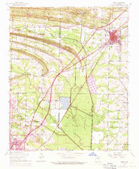
1954 Map of Cabot
USGS Topo · Published 1971About this map
Little Rock Air Force Base dominates the southwestern corner of this Lonoke and Pulaski County landscape, showing the military installation's early footprint alongside the established town of Jacksonville. The map captures a period of growth as residential and infrastructure expansions, shown in purple revision tint, began to surround the older agricultural grid. To the northeast, the town of Cabot serves as a hub for the Missouri Pacific railroad, while the rural interior is dotted with community centers like Mt Pleasant Church, Midway School, and Ebenezer Church. The topography is defined by low ridges such as Bone Ridge and several slow-moving water bodies, including Bayou Two Prairie and Bayou Meto. Local history is preserved through numerous family and community landmarks, from the Quapaw Mineral Spring to the Bayou Meto Cemetery, reflecting the area's transition from a rail-and-creek economy to a modern military and suburban center.
Find a feature on this map
41 named features on this map. Tap any name to fly to it.
Don’t see what you’re looking for? This feature index may not catch every label — zoom into the map to look around manually.
Map Details
Editions of this 1954 Cabot Map
3 editions found
Other maps of this area

1891 · Little Rock
USGS Topo · 1:125,000

1893 · Little Rock
USGS Topo · 1:125,000

1935 · Mc Almont
USGS Topo · 1:24,000

1940 · Lonoke
USGS Topo · 1:62,500

1941 · Olmstead
USGS Topo · 1:31,680

1941 · Cabot
USGS Topo · 1:31,680

1943 · Jacksonville
USGS Topo · 1:31,680

1948 · Helena
USGS Topo · 1:250,000

1949 · Lonoke
USGS Topo · 1:62,500

1950 · Helena
USGS Topo · 1:250,000