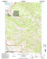
1996 Map of Cache Creek
USGS Topo · Published 1998About this map
Jackson sits at the edge of this survey, where the valley floor transitions into the high peaks of the Gros Ventre Range. The landscape is dominated by managed wilderness and conservation areas, including the southern portion of the Elk National Refuge and the expansive Gros Ventre Wilderness. This 1990s record details the intersection of public land management and historical resource extraction, evidenced by the Jackson Mine and Noker Mine tucked into the slopes near Cache Creek. The drainage patterns are intricate, with Flat Creek and the Snake River winding through the southwestern corner, while Horsethief Canyon and Woods Canyon carve deep paths into the mountains. Small-scale infrastructure like the Refuge Hdqrs and a Tank Trap suggest the localized activity within the Teton National Forest during this period.
Find a feature on this map
37 named features on this map. Tap any name to fly to it.
Don’t see what you’re looking for? This feature index may not catch every label — zoom into the map to look around manually.
Map Details
Editions of this 1996 Cache Creek Map
This is the sole edition of this map. No revisions or reprints were ever made.
Other maps of this area

1899 · Grand Teton
USGS Topo · 1:125,000

1901 · Grand Teton
USGS Topo · 1:125,000

1931 · Jackson
USGS Topo · 1:125,000

1935 · Jackson
USGS Topo · 1:125,000

1955 · Driggs
USGS Topo · 1:250,000

1958 · Driggs
USGS Topo · 1:250,000

1962 · Driggs
USGS Topo · 1:250,000

1963 · Munger Mountain
USGS Topo · 1:24,000

1963 · Jackson
USGS Topo · 1:24,000

1965 · Camp Davis
USGS Topo · 1:24,000