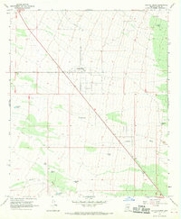
1966 Map of Cactus Forest
USGS Topo · Published 1969About this map
Cactus Forest and the surrounding desert landscape of Pinal County appear here as they were documented in the mid-1960s. The settlement pattern is defined by a sparse network of roads and isolated water improvements essential for livestock in this arid environment. Key transportation routes including Cactus Forest Road, Diffin Road, and Reed Road provide structure to the open terrain. The mapping reveals a distinct reliance on man-made water catchments, many bearing the names of local ranching families such as Youtsey Tank, Clemans Tank, and Jamieson Tank. To the south, Brady Wash cuts across the desert floor, while the northeast is marked by the modest elevation of the Cat Hills. The presence of small stopping points like Paisano and a highway Rest Area suggest the transition of this area from traditional ranching toward modern thoroughfares.
Find a feature on this map
21 named features on this map. Tap any name to fly to it.
Don’t see what you’re looking for? This feature index may not catch every label — zoom into the map to look around manually.
Map Details
Editions of this 1966 Cactus Forest Map
2 editions found
Other maps of this area

1900 · Florence
USGS Topo · 1:125,000

1902 · Florence
USGS Topo · 1:125,000

1922 · Red Rock No 2
USGS Topo · 1:48,000

1934 · Newman Peak
USGS Topo · 1:125,000

1954 · Mesa
USGS Topo · 1:250,000

1956 · Tucson
USGS Topo · 1:250,000

1957 · Mesa
USGS Topo · 1:250,000

1958 · Mesa
USGS Topo · 1:250,000

1958 · Tucson
USGS Topo · 1:250,000

1959 · Tucson
USGS Topo · 1:250,000