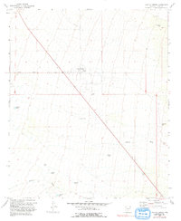
1966 Map of Cactus Forest
USGS Topo · Published 1993About this map
Cactus Forest serves as the focal point of this arid Pinal County landscape, situated along the straight path of Cactus Forest Road. The map, reflecting conditions verified through the mid-1960s, illustrates a rural Arizona environment where human presence is defined by essential water management. A series of catchment features, including Cat Hills Tank and Jamieson Tank, are distributed across the terrain, indicating the vital importance of water storage for ranching or local agriculture in this desert setting. The settlement of Paisano sits further south, connected to the surrounding region by Route 89. This infrastructure, alongside natural drainages like Brady Wash, shows how early twentieth-century development followed the contours of the land and the requirements of the climate, creating a network of named tanks and washes that served as critical landmarks for local residents and travelers alike.
Find a feature on this map
17 named features on this map. Tap any name to fly to it.
Don’t see what you’re looking for? This feature index may not catch every label — zoom into the map to look around manually.
Map Details
Editions of this 1966 Cactus Forest Map
2 editions found
Other maps of this area

1900 · Florence
USGS Topo · 1:125,000

1902 · Florence
USGS Topo · 1:125,000

1922 · Red Rock No 2
USGS Topo · 1:48,000

1934 · Newman Peak
USGS Topo · 1:125,000

1954 · Mesa
USGS Topo · 1:250,000

1956 · Tucson
USGS Topo · 1:250,000

1957 · Mesa
USGS Topo · 1:250,000

1958 · Mesa
USGS Topo · 1:250,000

1958 · Tucson
USGS Topo · 1:250,000

1959 · Tucson
USGS Topo · 1:250,000