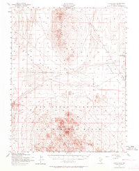
1952 Map of Cactus Peak
USGS Topo · Published 1964About this map
The Las Vegas Bombing and Gunnery Range dominates the southern half of this mid-century Nevada landscape, reflecting the military expansion of the Cold War era. Surveyed by the Army Map Service, the terrain transitions from the high peaks of the Monitor Range, including Monitor Peak, down into the broad expanse of Ralston Valley. The presence of several Targets, Target Areas, and observation towers scattered across the Cactus Flat highlights the area's specialized use for tactical training. Along the eastern edge, Reeds Ranch provides a rare point of named civilian activity in an otherwise austere high-desert environment. The mapping also captures the Mt Diablo Base Line, a critical surveying meridian that bisects the territory between the Cactus Range and the northern mountain peaks.
Find a feature on this map
14 named features on this map. Tap any name to fly to it.
Don’t see what you’re looking for? This feature index may not catch every label — zoom into the map to look around manually.
Map Details
Editions of this 1952 Cactus Peak Map
3 editions found

Other maps of this area

1907 · Tonopah
USGS Topo · 1:250,000

1908 · Kawich
USGS Topo · 1:250,000

1908 · Lida
USGS Topo · 1:250,000

1908 · Tonopah
USGS Topo · 1:250,000

1913 · Lida
USGS Topo · 1:250,000

1942 · Cactus Range
USGS Topo · 1:125,000

1945 · Goldfield
USGS Topo · 1:125,000

1952 · Stinking Spring
USGS Topo · 1:62,500

1952 · Mellan
USGS Topo · 1:62,500

1952 · Cactus Spring
USGS Topo · 1:62,500