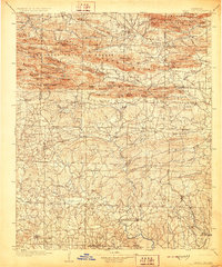
1906 Map of Caddo Gap
USGS Topo · Published 1928About this map
Arkansas National Forest dominates the northern reaches of this territory, where the complex ridges of the Missouri Mountains and Caddo Mountains define the terrain. The landscape is a network of deep gaps and high knobs, such as Hurricane Knob and Mc Kinley Mtn, which channeled early settlement and travel along narrow valley corridors. Small communities like Slatington and Black Springs appear along the Caddo River, while the southern portion of the map transitions into a more open, though still dissected, landscape featuring Centerpoint and Delight.
Find a feature on this map
96 named features on this map. Tap any name to fly to it.
Don’t see what you’re looking for? This feature index may not catch every label — zoom into the map to look around manually.
Map Details
Editions of this 1906 Caddo Gap Map
3 editions found
Other maps of this area

1890 · Mount Ida
USGS Topo · 1:125,000

1890 · Poteau Mountain
USGS Topo · 1:125,000

1890 · Hot Springs
USGS Topo · 1:125,000

1894 · Hot Springs
USGS Topo · 1:125,000

1899 · Poteau Mountain
USGS Topo · 1:125,000

1901 · Gurdon
USGS Topo · 1:125,000

1906 · Caddo Gap
USGS Topo · 1:125,000

1913 · De Queen
USGS Topo · 1:125,000

1936 · Athens
USGS Topo · 1:48,000

1936 · Glenwood
USGS Topo · 1:48,000