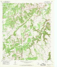
1967 Map of Caddo NE
USGS Topo · Published 1970About this map
The Palo Pinto Mountains define this Texas landscape, where sharp-cut ridges and deep creek valleys meet the industrial activity of the late 1960s. Surveyed just after the middle of the century, this area shows a transition from natural landmarks to an active oil-and-gas economy, with numerous Oil Wells peppered across the rugged terrain and a major Pipeline cutting across the southeastern corner. Water management is a central theme of the settlement pattern here, visible in localized features like Lone Star Lake, Mud Spring Tank, and Cedar Spring Tank. The boundary between Stephens and Palo Pinto Counties bisects the western half of the map, while drainage follows the paths of Little Caddo Creek and Ioni Creek. Cultural markers are sparse but notable, including a Roadside Park along the northern highway and a Gravel Pit near the county line.
Find a feature on this map
14 named features on this map. Tap any name to fly to it.
Don’t see what you’re looking for? This feature index may not catch every label — zoom into the map to look around manually.
Map Details
Editions of this 1967 Caddo NE Map
This is the sole edition of this map. No revisions or reprints were ever made.
Other maps of this area

1890 · Breckenridge
USGS Topo · 1:125,000

1891 · Palo Pinto
USGS Topo · 1:125,000

1918 · Palo Pinto
USGS Topo · 1:125,000

1924 · Palo Pinto 2-c
USGS Topo · 1:48,000

1924 · Breckenridge 1-d
USGS Topo · 1:48,000

1927 · Pickwick
USGS Topo · 1:62,500

1931 · Ivan
USGS Topo · 1:62,500

1954 · Abilene
USGS Topo · 1:250,000

1958 · Abilene
USGS Topo · 1:250,000

1958 · Palo Pinto
USGS Topo · 1:62,500