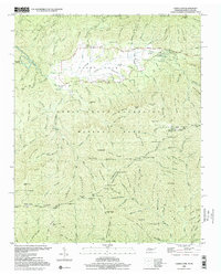
2000 Map of Cades Cove
USGS Topo · Published 2001About this map
Cades Cove serves as a preserved pocket of Tennessee homesteading history within the Great Smoky Mountains National Park. The landscape is dotted with historical structures that signify the valley's late 19th and early 20th-century life, including the John P Cable Mill Area, the Becky Cable House, and the Elijah Oliver Place. A well-defined Cades Cove Loop Road provides access to these sites, while the southern reaches of the map transition into the high ridges of the Smoky Mountains. This area is bisected by the Appalachian National Scenic Trail, which follows the state line between Tennessee and North Carolina. The drainage system is dominated by Abrams Creek and its many tributaries, such as Forge Creek and Mill Creek, which once powered the local mills and sustained the agricultural community before the land became parkland.
Find a feature on this map
140 named features on this map. Tap any name to fly to it.
Don’t see what you’re looking for? This feature index may not catch every label — zoom into the map to look around manually.
Map Details
Editions of this 2000 Cades Cove Map
This is the sole edition of this map. No revisions or reprints were ever made.
Other maps of this area

1886 · Knoxville
USGS Topo · 1:125,000

1892 · Knoxville
USGS Topo · 1:125,000

1894 · Knoxville
USGS Topo · 1:125,000

1895 · Knoxville
USGS Topo · 1:125,000

1901 · Knoxville
USGS Topo · 1:125,000

1933 · Bushnell
USGS Topo · 1:62,500

1935 · Fontana
USGS Topo · 1:24,000

1935 · Calderwood
USGS Topo · 1:24,000
1935 · Tapoco
USGS Topo · 1:24,000
1935 · Blockhouse
USGS Topo · 1:24,000