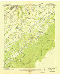
1935 Map of Blockhouse
USGS Topo · Published 1935About this map
Montvale Springs and the southern edge of Maryville anchor this 1935 Tennessee Valley Authority survey of Blount County. The landscape is defined by the rise of Chilhowee Mountain and the northwestern boundary of Great Smoky Mountains National Park, where the terrain transitions from the settled valley floor to the ridgelines at Ellis Knob and Murray Gap.
Find a feature on this map
67 named features on this map. Tap any name to fly to it.
Don’t see what you’re looking for? This feature index may not catch every label — zoom into the map to look around manually.
Map Details
Editions of this 1935 Blockhouse Map
2 editions found
Other maps of this area

1886 · Knoxville
USGS Topo · 1:125,000

1892 · Knoxville
USGS Topo · 1:125,000

1894 · Knoxville
USGS Topo · 1:125,000

1895 · Loudon
USGS Topo · 1:125,000

1895 · Knoxville
USGS Topo · 1:125,000

1901 · Knoxville
USGS Topo · 1:125,000

1935 · Binfield
USGS Topo · 1:24,000

1935 · Knoxville
USGS Topo · 1:48,000

1935 · Maryville
USGS Topo · 1:24,000

1935 · Wildwood
USGS Topo · 1:24,000