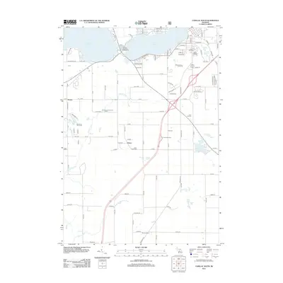
2012 Map of Cadillac South
USGS Topo · Published 2012About this map
Lake Cadillac and Lake Mitchell define this southern portion of the Cadillac area, where residential streets and recreation facilities meet the rural landscape of Wexford County. The map details a transition from the structured street grid of the city, featuring names like Michigan Ave and Marble St, to the outlying agricultural and forest lands. Notable family and community history is anchored by several burial grounds, including the Mount Carmel Cem and Maple Hill Cem near the town center, and more remote sites like the Green Family Cem near Hobart.
Find a feature on this map
64 named features on this map. Tap any name to fly to it.
Don’t see what you’re looking for? This feature index may not catch every label — zoom into the map to look around manually.
Map Details
Editions of this 2012 Cadillac South Map
This is the sole edition of this map. No revisions or reprints were ever made.
Other maps of this area

1933 · Luther SE
USGS Topo · 1:31,680

1954 · Traverse City
USGS Topo · 1:250,000

1956 · Mesick
USGS Topo · 1:62,500

1956 · Cadillac North
USGS Topo · 1:62,500

1957 · Cadillac South
USGS Topo · 1:62,500

1957 · Luther
USGS Topo · 1:62,500

1958 · Traverse City
USGS Topo · 1:250,000
1983 · Dighton
USGS Topo · 1:25,000

1983 · Cadillac
USGS Topo · 1:100,000
1983 · Le Roy
USGS Topo · 1:25,000