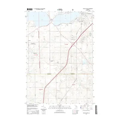
2014 Map of Cadillac South
USGS Topo · Published 2014About this map
Lake Cadillac and Lake Mitchell anchor the northern landscape of this Wexford County region, where the city of Cadillac meets the dense woodlands of the Manistee National Forest. This 2014 survey captures a rural landscape defined by glacial topography and established family heritage. Numerous cemeteries, including the Green Family Cem and Mt Carmel Cem, are scattered across the terrain, marking the sites of early homesteads and community hubs like Hobart and Wedgewood. The transition from the urban grid of Cadillac to the meandering courses of the N Br Pine River and E Br Pine River illustrates the area's dual character as both a developed regional center and a gateway to Michigan's interior wilderness. Small, isolated water bodies like Stone Ledge Lake and Bommer Lake dot the southern townships, providing a detailed record of the local hydrology.
Find a feature on this map
70 named features on this map. Tap any name to fly to it.
Don’t see what you’re looking for? This feature index may not catch every label — zoom into the map to look around manually.
Map Details
Editions of this 2014 Cadillac South Map
This is the sole edition of this map. No revisions or reprints were ever made.
Other maps of this area

1933 · Luther SE
USGS Topo · 1:31,680

1954 · Traverse City
USGS Topo · 1:250,000

1956 · Mesick
USGS Topo · 1:62,500

1956 · Cadillac North
USGS Topo · 1:62,500

1957 · Cadillac South
USGS Topo · 1:62,500

1957 · Luther
USGS Topo · 1:62,500

1958 · Traverse City
USGS Topo · 1:250,000
1983 · Dighton
USGS Topo · 1:25,000

1983 · Cadillac
USGS Topo · 1:100,000
1983 · Le Roy
USGS Topo · 1:25,000