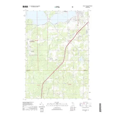
2019 Map of Cadillac South
USGS Topo · Published 2019About this map
The south side of Cadillac and its surrounding rural landscapes are captured here in 2019, showing a region defined by the proximity of Lake Mitchell and Lake Cadillac. The terrain transitions from the developed street grid of the city, featuring roads like Whaley St and Sunnyside Dr, into the wooded expanses of the Manistee National Forest. This survey illustrates the modern reuse of older infrastructure, most notably the Fred Meijer White Pine Trail State Park, which follows a former rail corridor through the countryside.
Find a feature on this map
89 named features on this map. Tap any name to fly to it.
Don’t see what you’re looking for? This feature index may not catch every label — zoom into the map to look around manually.
Map Details
Editions of this 2019 Cadillac South Map
This is the sole edition of this map. No revisions or reprints were ever made.
Other maps of this area

1933 · Luther SE
USGS Topo · 1:31,680

1954 · Traverse City
USGS Topo · 1:250,000

1956 · Mesick
USGS Topo · 1:62,500

1956 · Cadillac North
USGS Topo · 1:62,500

1957 · Cadillac South
USGS Topo · 1:62,500

1957 · Luther
USGS Topo · 1:62,500

1958 · Traverse City
USGS Topo · 1:250,000
1983 · Dighton
USGS Topo · 1:25,000

1983 · Cadillac
USGS Topo · 1:100,000
1983 · Le Roy
USGS Topo · 1:25,000