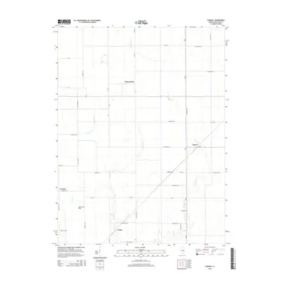
2015 Map of Cadwell
USGS Topo · Published 2015About this map
Williamsburg and Cadwell anchor this agricultural landscape in Moultrie County, where a strictly rectilinear grid of section roads defines the modern rural economy. The terrain is marked by the subtle drainage patterns of Jonathan Cr and its tributaries, including Jonathan Br and Twomile Br, which cut through the level plains of central Illinois. Near the settlement of Chipps, the land sinks toward the Eagle Lake Basin, a notable local depression that contrasts with the surrounding farm tracts. Genealogists will find the Seass Cem located along N 1475 East Rd, while aviation history is represented by the presence of Durbin Airport in the southwest corner near Cushman. The map captures a highly organized township structure, where residential developments like Evergreen Acrs begin to appear along established county routes.
Find a feature on this map
47 named features on this map. Tap any name to fly to it.
Don’t see what you’re looking for? This feature index may not catch every label — zoom into the map to look around manually.
Map Details
Editions of this 2015 Cadwell Map
This is the sole edition of this map. No revisions or reprints were ever made.
Other maps of this area

1935 · Arcola
USGS Topo · 1:48,000

1935 · Sullivan
USGS Topo · 1:48,000

1940 · Sullivan
USGS Topo · 1:62,500

1940 · Arcola
USGS Topo · 1:62,500

1950 · Tuscola
USGS Topo · 1:62,500

1955 · Bement
USGS Topo · 1:62,500

1958 · Decatur
USGS Topo · 1:250,000

1961 · Decatur
USGS Topo · 1:250,000
1975 · Tuscola SW
USGS Topo · 1:24,000
1975 · Bement SE
USGS Topo · 1:24,000