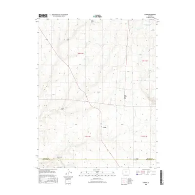
2016 Map of Cahone
USGS Topo · Published 2016About this map
Cahone serves as the primary settlement on this portion of the Colorado Plateau, situated at a junction near the boundary between Dolores and Montezuma counties. The landscape is defined by a dense network of high-desert drainage systems, including the dramatic incisions of Cahone Canyon and Little Cahone Canyon to the south. This area demonstrates a sophisticated reliance on water management in an arid environment, shown through the positioning of the Dove Cr Canal and several high-altitude catchments like the Mel Dalton Number One Reservoir and Sagebrush Number One Reservoir. The map illustrates a transition from the rugged canyons of the west, such as Cross Canyon and Sharp Canyon, to more organized agricultural and residential plots along the grid of county roads that service this rural ranching and farming community.
Find a feature on this map
31 named features on this map. Tap any name to fly to it.
Don’t see what you’re looking for? This feature index may not catch every label — zoom into the map to look around manually.
Map Details
Editions of this 2016 Cahone Map
This is the sole edition of this map. No revisions or reprints were ever made.
Other maps of this area

1956 · Cortez
USGS Topo · 1:250,000

1957 · Cedar 3 NW
USGS Topo · 1:24,000

1957 · Cedar 3 SW
USGS Topo · 1:24,000

1958 · Cortez
USGS Topo · 1:250,000

1959 · Cortez
USGS Topo · 1:250,000

1962 · Cortez
USGS Topo · 1:250,000
1964 · Secret Canyon
USGS Topo · 1:24,000

1964 · The Glade
USGS Topo · 1:24,000
1964 · Dove Creek
USGS Topo · 1:24,000

1965 · Cahone
USGS Topo · 1:24,000