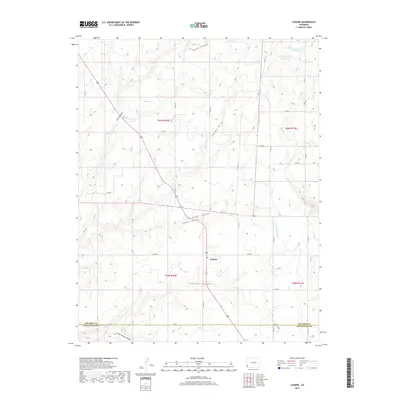
2019 Map of Cahone
USGS Topo · Published 2019About this map
Cahone sits near the heart of this landscape, positioned along a network of county roads that traverse the high plateau between deeply incised drainage systems. The settlement is defined by its proximity to the head of Cahone Canyon, where the terrain begins its dramatic descent toward the southwest. This era of land management is marked by an extensive water storage system in the northeast, featuring the Mel Dalton Number One Reservoir, Sagebrush Number One Reservoir, and Dove Reservoir, all linked by the Dove Cr Canal. These features highlight the importance of irrigation and water control in this semi-arid region of Dolores County. To the south, the boundary between Dolores Co and Montezuma Co is delineated near Little Cahone Canyon, reflecting the administrative divisions of the Four Corners region.
Find a feature on this map
30 named features on this map. Tap any name to fly to it.
Don’t see what you’re looking for? This feature index may not catch every label — zoom into the map to look around manually.
Map Details
Editions of this 2019 Cahone Map
This is the sole edition of this map. No revisions or reprints were ever made.
Other maps of this area

1956 · Cortez
USGS Topo · 1:250,000

1957 · Cedar 3 NW
USGS Topo · 1:24,000

1957 · Cedar 3 SW
USGS Topo · 1:24,000

1958 · Cortez
USGS Topo · 1:250,000

1959 · Cortez
USGS Topo · 1:250,000

1962 · Cortez
USGS Topo · 1:250,000
1964 · Secret Canyon
USGS Topo · 1:24,000

1964 · The Glade
USGS Topo · 1:24,000
1964 · Dove Creek
USGS Topo · 1:24,000

1965 · Cahone
USGS Topo · 1:24,000