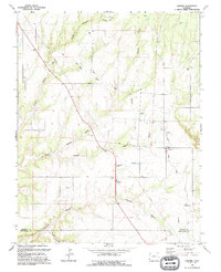
1994 Map of Cahone
USGS Topo · Published 1994About this map
Cahone sits as a primary settlement within this high-desert landscape, serving as a hub for local infrastructure and community life in the late twentieth century. The town is marked by its P O and Recreation Hall, while the surrounding geography is defined by a sophisticated network of water management features designed to navigate the broken terrain. Extensive engineering works including the Dove Creek Siphon, Canal Siphon, and the Dove Creek Aqueduct underscore the vital importance of irrigation in this region, where deep drainages like Cahone Canyon and Alkali Canyon carve through the plateau. This 1994 revision captures the intersection of ranching-era legacy and modern utility, from the small Cem to the industrial presence of the Cahone Pumping Sta and scattered Gas Wells.
Find a feature on this map
31 named features on this map. Tap any name to fly to it.
Don’t see what you’re looking for? This feature index may not catch every label — zoom into the map to look around manually.
Map Details
Editions of this 1994 Cahone Map
This is the sole edition of this map. No revisions or reprints were ever made.
Other maps of this area

1956 · Cortez
USGS Topo · 1:250,000

1957 · Cedar 3 NW
USGS Topo · 1:24,000

1957 · Cedar 3 SW
USGS Topo · 1:24,000

1958 · Cortez
USGS Topo · 1:250,000

1959 · Cortez
USGS Topo · 1:250,000

1962 · Cortez
USGS Topo · 1:250,000
1964 · Secret Canyon
USGS Topo · 1:24,000

1964 · The Glade
USGS Topo · 1:24,000
1964 · Dove Creek
USGS Topo · 1:24,000

1965 · Cahone
USGS Topo · 1:24,000