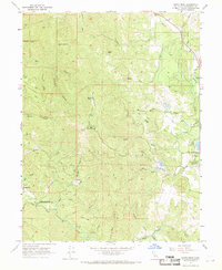
1967 Map of Cahto Peak
USGS Topo · Published 1969About this map
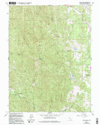
Laytonville Rancheria occupies the eastern portion of this Mendocino County landscape, situated near the headwaters of Cahto Creek. The terrain is defined by the high elevations of the Coast Range, including Cahto Peak, which features a Lookout Tower and Radio Facility, alongside Signal Peak and the curiously named Staten Opening. This 1967 field-checked survey reveals a network of primitive transportation, with numerous labels for Jeep Trails and standard Trails threading through the steep ridges and canyons. The South Fork Eel River cuts across the southwest corner, joined by tributaries like Wise Gulch and Windem Creek. Human activity is concentrated around the small settlement of Branscomb, where a local Cemetery is marked. Notable land use includes the Admiral Standley State Recreation Area and a historical Mill site located along the upper reaches of Mill Creek.
Find a feature on this map
42 named features on this map. Tap any name to fly to it.
Don’t see what you’re looking for? This feature index may not catch every label — zoom into the map to look around manually.
Map Details
Editions of this 1967 Cahto Peak Map
5 editions found
Other maps of this area

1920 · Cummings
USGS Topo · 1:62,500

1920 · Covelo
USGS Topo · 1:62,500

1921 · Branscomb
USGS Topo · 1:62,500

1951 · Branscomb
USGS Topo · 1:62,500

1951 · Laytonville
USGS Topo · 1:62,500

1952 · Spyrock
USGS Topo · 1:62,500

1952 · Leggett
USGS Topo · 1:62,500

1957 · Ukiah
USGS Topo · 1:250,000

1960 · Ukiah
USGS Topo · 1:250,000
1966 · Dutchmans Knoll
USGS Topo · 1:24,000