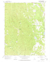
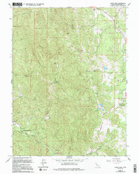
1967 Map of Cahto Peak
USGS Topo · Published 1977About this map
Cahto Peak and Signal Peak dominate this section of the Coast Range, where the drainage systems of Tenmile Creek and the South Fork Eel River begin to diverge. The landscape is defined by a dense network of ridges and watercourses, including the remote Admiral Standley State Recreation Area and the Laytonville Rancheria on the eastern edge. Local history is anchored by the small settlement of Branscomb in the southwest, while more ephemeral landmarks like the Lookout Tower and Radio Facility atop the peaks indicate the era's fire watch and communication infrastructure. Genealogists may note the Cem located near Branscomb, while old routes such as the Peterson Trail and various unnamed jeep trails provide evidence of early access through the timbered heights of Black Oak Mtn and Sand Rock.
Find a feature on this map
51 named features on this map. Tap any name to fly to it.
Don’t see what you’re looking for? This feature index may not catch every label — zoom into the map to look around manually.
Map Details
Editions of this 1967 Cahto Peak Map
5 editions found
Other maps of this area

1920 · Cummings
USGS Topo · 1:62,500

1920 · Covelo
USGS Topo · 1:62,500

1921 · Branscomb
USGS Topo · 1:62,500

1951 · Branscomb
USGS Topo · 1:62,500

1951 · Laytonville
USGS Topo · 1:62,500

1952 · Spyrock
USGS Topo · 1:62,500

1952 · Leggett
USGS Topo · 1:62,500

1957 · Ukiah
USGS Topo · 1:250,000

1960 · Ukiah
USGS Topo · 1:250,000
1966 · Dutchmans Knoll
USGS Topo · 1:24,000