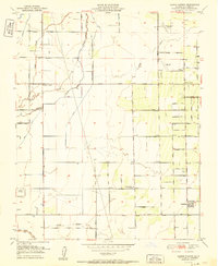
1951 Map of Cairns Corner
USGS Topo · Published 1951About this map
Governor Earl Warren and state engineers oversaw the documentation of this agricultural landscape in the San Joaquin Valley during the mid-century. The map captures a transition in rural education and aviation, noted by the presence of the Prairie Center Sch (Aban'd) and multiple landing strips including Rankin Airfield and the Exeter-Lindsay Airport. The terrain is defined by an intricate network of water management, with Porter Slough and the North Branch Tule River cutting through the southern sections.
Find a feature on this map
40 named features on this map. Tap any name to fly to it.
Don’t see what you’re looking for? This feature index may not catch every label — zoom into the map to look around manually.
Map Details
Editions of this 1951 Cairns Corner Map
2 editions found
Other maps of this area

1925 · Rocky Hill
USGS Topo · 1:31,680

1925 · Tulare
USGS Topo · 1:31,680

1925 · Tipton
USGS Topo · 1:31,680

1926 · Exeter
USGS Topo · 1:31,680

1927 · Cairns Corner
USGS Topo · 1:31,680

1927 · Rocky Hill
USGS Topo · 1:31,680

1927 · Visalia
USGS Topo · 1:31,680

1927 · Tulare
USGS Topo · 1:31,680

1928 · Tipton
USGS Topo · 1:31,680

1928 · Woodville
USGS Topo · 1:31,680