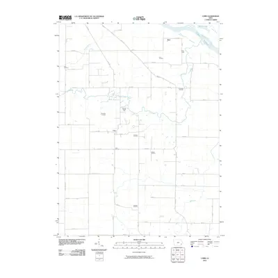
2010 Map of Cairo
USGS Topo · Published 2010About this map
Cairo sits at the heart of this southeast Iowa agricultural landscape, characterized by a dense network of family and community burial grounds that speak to generations of local residency. The terrain is defined by the winding course of Long Creek and the broad Iowa River in the northeast corner, where Schlitzing Lake and Indian Creek meet the main channel. A significant industrial footprint is visible at the Cairo Gas Storage Field, illustrating the area's role in regional energy infrastructure. Genealogists will find a concentration of historic sites including the Grim, Slaughter, and Griswold cemeteries scattered among the section lines and rural roads such as Co Rd X37. The small settlement of Bard and numerous creek crossings, including Johnny Creek and Roff Creek, further define the rural character of this Louisa County quadrangle.
Find a feature on this map
43 named features on this map. Tap any name to fly to it.
Don’t see what you’re looking for? This feature index may not catch every label — zoom into the map to look around manually.
Map Details
Editions of this 2010 Cairo Map
This is the sole edition of this map. No revisions or reprints were ever made.
Other maps of this area

1946 · Wapello
USGS Topo · 1:62,500

1948 · Muscatine
USGS Topo · 1:62,500

1949 · Wapello
USGS Topo · 1:62,500

1958 · Davenport
USGS Topo · 1:250,000

1961 · Davenport
USGS Topo · 1:250,000

1962 · Davenport
USGS Topo · 1:250,000
1965 · Mediapolis
USGS Topo · 1:24,000

1965 · Letts
USGS Topo · 1:24,000
1965 · Wapello
USGS Topo · 1:24,000

1970 · Cotter
USGS Topo · 1:24,000