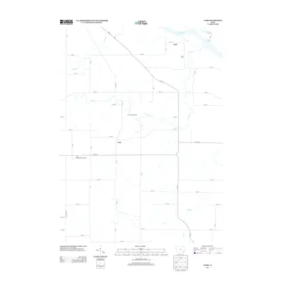
2013 Map of Cairo
USGS Topo · Published 2013About this map
Cairo sits at the heart of this agricultural landscape in Louisa County, where the regular grid of rural roads is interrupted only by the winding paths of local waterways. The northeastern corner of the map is defined by the Iowa River, which feeds into Schlitzing Lake and is joined by the meandering course of Long Creek. This area illustrates the intersection of traditional farming and modern industrial infrastructure, most notably the Cairo Gas Storage Field which occupies a significant portion of the terrain north of the primary settlement. Evidence of local aviation is seen at the Port Paradise Farms Airport, located west of the main crossroads. Small drainage features like Johnny Cr and Roff Cr carve through the fields, illustrating the natural drainage patterns that have shaped the local topography and land use for generations of Iowa farmers.
Find a feature on this map
38 named features on this map. Tap any name to fly to it.
Don’t see what you’re looking for? This feature index may not catch every label — zoom into the map to look around manually.
Map Details
Editions of this 2013 Cairo Map
This is the sole edition of this map. No revisions or reprints were ever made.
Other maps of this area

1946 · Wapello
USGS Topo · 1:62,500

1948 · Muscatine
USGS Topo · 1:62,500

1949 · Wapello
USGS Topo · 1:62,500

1958 · Davenport
USGS Topo · 1:250,000

1961 · Davenport
USGS Topo · 1:250,000

1962 · Davenport
USGS Topo · 1:250,000
1965 · Mediapolis
USGS Topo · 1:24,000

1965 · Letts
USGS Topo · 1:24,000
1965 · Wapello
USGS Topo · 1:24,000

1970 · Cotter
USGS Topo · 1:24,000