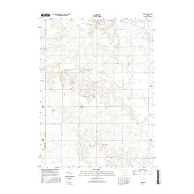
2015 Map of Cairo
USGS Topo · Published 2015About this map
The settlement of Cairo serves as the focal point for this section of Louisa County, situated amidst a landscape defined by the meandering courses of the Iowa River and Long Creek. The topography is marked by the distinct transition from the river bottomlands to the dissected uplands, a pattern reflected in the placement of numerous family and community burial grounds. Genealogists will find significant value in the documentation of local sites such as Virginia Grove Cem, Marshall Cem, and the Griswold Cem. The area maintains its agricultural character, evidenced by the grid of county roads and the presence of the Port Paradise Farms Airport near the border of Henry and Louisa Counties. The drainage patterns of Johnny Cr and Indian Cr further detail the complex watershed that has shaped the region's development and land use through the early 21st century.
Find a feature on this map
38 named features on this map. Tap any name to fly to it.
Don’t see what you’re looking for? This feature index may not catch every label — zoom into the map to look around manually.
Map Details
Editions of this 2015 Cairo Map
This is the sole edition of this map. No revisions or reprints were ever made.
Other maps of this area

1946 · Wapello
USGS Topo · 1:62,500

1948 · Muscatine
USGS Topo · 1:62,500

1949 · Wapello
USGS Topo · 1:62,500

1958 · Davenport
USGS Topo · 1:250,000

1961 · Davenport
USGS Topo · 1:250,000

1962 · Davenport
USGS Topo · 1:250,000
1965 · Mediapolis
USGS Topo · 1:24,000

1965 · Letts
USGS Topo · 1:24,000
1965 · Wapello
USGS Topo · 1:24,000

1970 · Cotter
USGS Topo · 1:24,000